


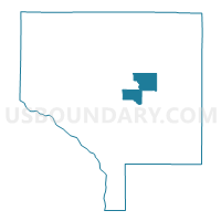
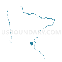
Ham Lake P-4, Anoka County, Minnesota
About
Outline

Summary
| Unique Area Identifier | 601015 |
| Name | Ham Lake P-4 |
| County | Anoka County |
| State | Minnesota |
| Area (square miles) | 9.31 |
| Land Area (square miles) | 8.26 |
| Water Area (square miles) | 1.05 |
| % of Land Area | 88.75 |
| % of Water Area | 11.25 |
| Latitude of the Internal Point | 45.27270070 |
| Longtitude of the Internal Point | -93.17913190 |
Maps

Graphs
Select a template below for downloading or customizing gragh for Ham Lake P-4, Anoka County, Minnesota


Neighbors
Neighoring Voting District (by Name) Neighboring Voting District on the Map
- Columbus P-1, Anoka County, MN
- East Bethel P-2, Anoka County, MN
- East Bethel P-3, Anoka County, MN
- Ham Lake P-1, Anoka County, MN
- Ham Lake P-2, Anoka County, MN
- Ham Lake P-3, Anoka County, MN
- Ham Lake P-5, Anoka County, MN
- Ham Lake P-6, Anoka County, MN
Top 10 Neighboring County Subdivision (by Population) Neighboring County Subdivision on the Map
- Ham Lake city, Anoka County, MN (15,296)
- East Bethel city, Anoka County, MN (11,626)
- Columbus city, Anoka County, MN (3,914)
Top 10 Neighboring Place (by Population) Neighboring Place on the Map
Top 10 Neighboring Unified School District (by Population) Neighboring Unified School District on the Map
- Anoka-Hennepin Public School District, MN (226,412)
- Forest Lake Public School District, MN (45,564)
- St. Francis Public School District, MN (31,633)
Top 10 Neighboring State Legislative District Lower Chamber (by Population) Neighboring State Legislative District Lower Chamber on the Map
- State House District 52A, MN (47,548)
- State House District 48A, MN (45,476)
- State House District 49A, MN (43,390)
Top 10 Neighboring State Legislative District Upper Chamber (by Population) Neighboring State Legislative District Upper Chamber on the Map
- State Senate District 52, MN (90,197)
- State Senate District 48, MN (86,286)
- State Senate District 49, MN (80,494)
Top 10 Neighboring 111th Congressional District (by Population) Neighboring 111th Congressional District on the Map
Top 10 Neighboring Census Tract (by Population) Neighboring Census Tract on the Map
- Census Tract 502.16, Anoka County, MN (5,474)
- Census Tract 502.15, Anoka County, MN (4,192)
- Census Tract 502.10, Anoka County, MN (3,914)
- Census Tract 501.11, Anoka County, MN (3,709)
- Census Tract 502.34, Anoka County, MN (2,861)
- Census Tract 502.35, Anoka County, MN (2,769)
- Census Tract 501.10, Anoka County, MN (2,715)